

Wednesday, June 10, 2015


Wednesday, April 29, 2015


Tuesday, April 28, 2015
Wednesday, April 22, 2015
Sunday, April 19, 2015
Dotted i
As it appears to be the season of certain types of people announcing intentions to run for president there's been little poofs of hubbub about the various logos different candidates have chosen, from similarities of Ted Cruz's presidential logo and things he probably doesn't want to be associated with to a Hillary-logo-based font.
Marco Rubio's presidential campaign logo is at least geographically interesting in that he's dotted his I with an outline of the (contiguous) United States. It's not entirely clear how the nation's two newest states might feel about this.

Marco Rubio's presidential campaign logo is at least geographically interesting in that he's dotted his I with an outline of the (contiguous) United States. It's not entirely clear how the nation's two newest states might feel about this.
Saturday, April 18, 2015
Shall not be named
Maybe you saw the news item and/or video about the colossal pile of stupid that was the Florida governor's office telling environmental officials not to use the term climate change. Here's a cartoon about that from Ethan Diamond:

Saturday, April 11, 2015
Forced argument
This is a bit far for cartoonist Ethan Diamond at Unscene Comedy to go for the punchline:

Friday, April 10, 2015
Starbucks geo-quiz
There's an interactive quiz at Slate.com where you can guess the city by looking at a map showing only Starbucks locations. I got 8 out of 14. It's actually an update to a similar quiz they did a couple years ago.

Thursday, April 9, 2015
Movie geography
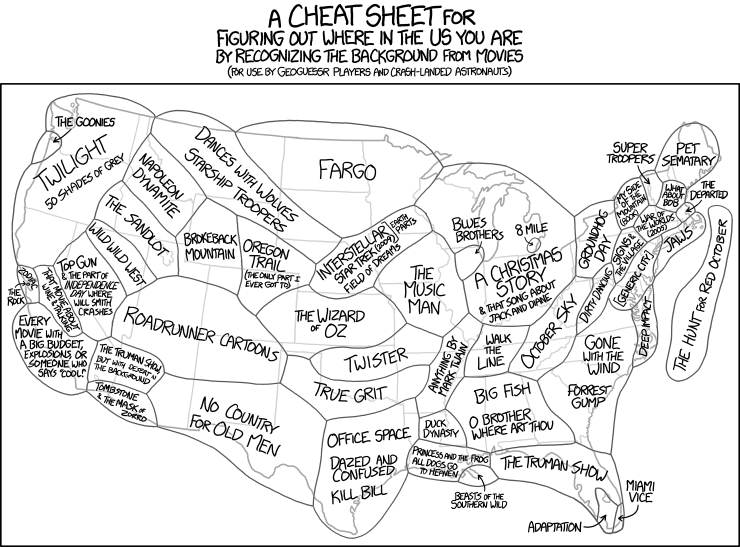
I'm beginning to think that Randall Munroe makes xkcd panels specifically for this blog. This one reminds me of the map showing which parts of California Hollywood uses to shoot locations that it doesn't have to budget to film in. And it'd be interesting to examine how much correlation there is between this map and the plot geography map.
That said, "title-text" at the actual webcomic says:

That said, "title-text" at the actual webcomic says:
At the boundary between each zone, stories blend together. Somewhere in the New Mexico desert, the Roadrunner is pursued by a tireless Anton Chigurh.
Wednesday, April 8, 2015
Interactive
Designer Nigel Evan Dennis has an elegant, yet extensive, minimalist compendium for Game Of Thrones on his website, Where The Wildlings Are, Dennis delves deep into the world of Westeros with beautifully designed maps, timelines, character portraits, and more.

Tuesday, April 7, 2015
Minimalist maps
Over at Flowing Data they keep pumping out compelling data visualizations. Michael Pecirno created a set of "minimalist maps" each showing the density of just one thing in the U.S.

Friday, April 3, 2015
Broad City
Abbi Jacobson, the actor/writer/maker of stuff who birthed the character Abbi Abrams on Comedy Central's show, "Broad City", is an artist who made a map of Broad City. Here's an interview/article with/about her.

Wednesday, April 1, 2015
Google PacMan
Google was a day or two early on their map-based April Fool's stunt allowing users to play PacMan on anyplace on Google Maps. Give it a shot:

Monday, March 23, 2015

Friday, March 20, 2015

Thursday, March 19, 2015
Orientation
We've seen gags where the map of the Earth is upside-down. This xkcd panel by Randall Munroe is a different take on that theme.
That said, "title-text" at the actual webcomic says:

That said, "title-text" at the actual webcomic says:
Due to their proximity across the channel, there's long been tension between North Korea and the United Kingdom of Great Britain and Southern Ireland.
Wednesday, March 18, 2015
Zombie interactive
I'm still no fan of the zombie genre, but I am a fan of interactive maps. This one created by Cornell researcher Matt Bierbaum can help you envision what the zombie apocalypse would look like.
Tuesday, March 17, 2015

Monday, March 16, 2015
Here There Be...
Guest poster Amanda here with a governing tip from SMBC Comics:

(Image links to source.)
Monday, March 9, 2015
Blast from the Past (well, more of a mist)
Here's a map in a cartoon about the H1N1 vaccine from 2009 from your friendly neighbo(u)rhood guest blogger, Amanda:

Jimmy Margulies, NorthJersey.com, 2009
Saturday, March 7, 2015
Friday, March 6, 2015
Thursday, March 5, 2015


Wednesday, March 4, 2015
Here comes the sun
Here's some panels from Ryan Seby, new to the blog. We've seen this gag before from AccordingtoDevin webcomic.

Tuesday, March 3, 2015
Topographic sandbox
Friend of blog Clint found this video of an intensely interactive topographic map sandbox.
Monday, March 2, 2015
Even More Historical Caricatures!
During
some research, I came across a collection of caricature anthologies that
feature "great men" from various geographic areas. Many of the
caricatures from these collections included globes.
Here
we have A. B. Newman on page 343 of Chicagoans As We See 'Em, circa 1904:

- Amanda Murphyao
Sunday, March 1, 2015
Maps by state
Here's a pair of map-by-state maps:
First the most used words in online dating sites by state
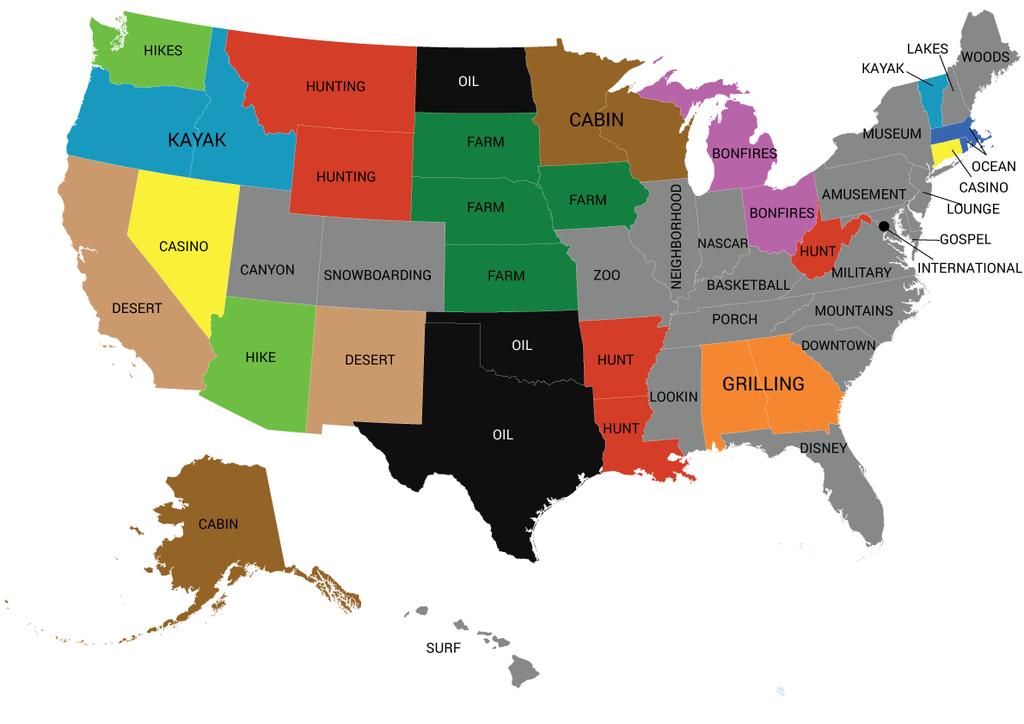
And then favorite stores

First the most used words in online dating sites by state
And then favorite stores
Saturday, February 28, 2015

Friday, February 27, 2015
Do you know what you know?
BuzzFeed gives a great video about issues that can arise from casual geographic education:
Thursday, February 26, 2015
Dog's world
One of the slides in this animated GIF slideshow from College Humor shows how dog's think of the planet:

Wednesday, February 25, 2015
Introducing Camp Weedonwantcha
Camp Weedonwantcha, by Katie Rice is a brilliant little webcomic about a batch of kids stranded at an endless summer camp. It would appear that they may be starting a new map-based story arc.

Tuesday, February 24, 2015
Spidey tracker
Did you know that Spiderman encountered GPS tracking devices in 1977? Well, ok, it was actually an "electronic radar device". Still, what a nifty idea! Maybe that's how Spiderman figured out how to make a tracking device better than GPS.

Monday, February 23, 2015
Even More Historical Caricatures!
During
some research, I came across a collection of caricature anthologies that
feature "great men" from various geographic areas. Many of the
caricatures from these collections included globes.
Here
we have John B. Murphy on page 101 of Chicagoans As We See 'Em, circa 1904:

- Amanda Murphyao
Sunday, February 22, 2015
GPS the bears
Jack Elrod's Mark Trail recently mentions GPS in a Sunday strip that serves up some rather alarming information about bears. 
Saturday, February 21, 2015
Colored orientation
This is a bunch of city maps by Stephen Von Worley showing streets colored according to orientation:
 |
| San Francisco |
 |
| London |
 |
| Tokyo |
 |
| New York |
Friday, February 20, 2015

Thursday, February 19, 2015
International Breakfast
What happens when a bunch of Yankee kids are asked to try out breakfast foods from around the world? The folks at Cut Video decided to find out.
Wednesday, February 18, 2015
Tuesday, February 17, 2015
Five Oceans (not to be confused with Seven Seas)
Friend-of-blog Susan has contributed this item that was new information for me: The Southern Ocean is the world's 5th ocean, where previously there had only been 4 defined, and it was only officially defined by the International Hydrographic Organization in 2000.

I already knew about the 5 oceans, but I hadn't realized The Southern Ocean's designation was so recent. I'll admit that when I was smaller I was very confused about mentions of The Seven Seas in pirate stories and my inability to match that with an equal number of oceans on the National Geographic world map that was in our family's dining room. Then I figured that The Seven Seas weren't referring to oceans, but rather to smaller bodies of water that Pirates frequented in the Golden Age of piracy... but I never bothered to learn what those Seven Seas were supposed to be.
Turns out that's not right either. The Seven Seas did, in fact, refer to all the world's oceans... as they were known as early as Ancient Sumeria some 4300 years ago. The number 7 of them was used to match up with astrology, there being 7 known planets (until somebody found Neptune in the 1700s).
Medieval Arabian literature identifies the Seven Seas as the Persian Gulf ("Sea of Fars"), the Gulf of Aden ("Sea of Larwi"), the Bay of Bengal ("Sea of Harkand"), the Strait of Malacca ("Sea of Kalah"), the Singapore Strait ("Sea of Salahit"), the Gulf of Thailand ("Sea of Kardanj"), and the South China Sea ("Sea of Sanji").
But Medieval Arabian literature also referenced other Seven Seas:
The Black Sea
The Caspian Sea
The Arabian Sea
The Indian Ocean
The Red Sea
The Mediterranean Sea
The Adriatic Sea
I already knew about the 5 oceans, but I hadn't realized The Southern Ocean's designation was so recent. I'll admit that when I was smaller I was very confused about mentions of The Seven Seas in pirate stories and my inability to match that with an equal number of oceans on the National Geographic world map that was in our family's dining room. Then I figured that The Seven Seas weren't referring to oceans, but rather to smaller bodies of water that Pirates frequented in the Golden Age of piracy... but I never bothered to learn what those Seven Seas were supposed to be.
Turns out that's not right either. The Seven Seas did, in fact, refer to all the world's oceans... as they were known as early as Ancient Sumeria some 4300 years ago. The number 7 of them was used to match up with astrology, there being 7 known planets (until somebody found Neptune in the 1700s).
Medieval Arabian literature identifies the Seven Seas as the Persian Gulf ("Sea of Fars"), the Gulf of Aden ("Sea of Larwi"), the Bay of Bengal ("Sea of Harkand"), the Strait of Malacca ("Sea of Kalah"), the Singapore Strait ("Sea of Salahit"), the Gulf of Thailand ("Sea of Kardanj"), and the South China Sea ("Sea of Sanji").
But Medieval Arabian literature also referenced other Seven Seas:
The Black Sea
The Caspian Sea
The Arabian Sea
The Indian Ocean
The Red Sea
The Mediterranean Sea
The Adriatic Sea
Medieval European literature referenced a somewhat different list of Seven Seas:
The Adriatic Sea
The Mediterranean Sea, including its marginal seas, notably the Aegean Sea.
The Black Sea
The Caspian Sea
The Persian Gulf
The Arabian Sea (which is part of the Indian Ocean)
The Red Sea, including the closed Dead Sea and the Sea of Galilee
And sometimes the list included a few others:
The Atlantic Ocean
The Aegean Sea
The Indian Ocean
The North Sea
So the Seven Seas hasn't had much significance for several hundred years at least.
Monday, February 16, 2015
First Partition of Poland
I could've sworn this one has shown up on the blog before, but I can't find it when Amanda sent it to me. This is The Allegory of the First Partition of Poland by Noël Le Mire:

It's after The Troelfth Cake, a 1773 French allegory by Jean-Michel Moreau le Jeune and there have been a number of versions of this rather iconic early political cartoon:


Sunday, February 15, 2015
Clean out the fridge!
Last month we had a comic from Twistedspeedo by Henrik Tomenius. Here's another:

Saturday, February 14, 2015


Subscribe to:
Posts (Atom)