Here's an episode of SciShow with information about mapping the ocean floor. Nifty!:

Showing posts with label satellites. Show all posts
Showing posts with label satellites. Show all posts
Sunday, November 2, 2014


Monday, June 30, 2014
Relax (guest post)
Hello! Guest contributor Amanda Murphyao here. I'm putting up cartoons involving the world or globe for the next few Mondays.


The signature is a bit difficult to make out, but I believe it's:
Jim Borgman - Cincinnati - 1985
From "Target: The Political Cartoon Quarterly"
Tuesday, May 6, 2014
Wham!
Between 2000 and 2013, 26 asteroids packing at least the energy of 1 kilotonne of TNT hit Earth or exploded in its atmosphere. That's up to 10 times as many as you would expect from existing models of the frequency of asteroid strikes.
These strikes were partially detected by the Comprehensive Nuclear Test Ban Detection Network, which monitors for the covert testing of nuclear weapons. Now the B612 Foundation, which is building the first privately funded asteroid-hunting space telescope, has turned the underlying data into a visualization.
B612 released this animation/visualization of those impacts. It's not clear whether this 13 years of data shows more asteroid impact activity than usual or if it's par for the course.
These strikes were partially detected by the Comprehensive Nuclear Test Ban Detection Network, which monitors for the covert testing of nuclear weapons. Now the B612 Foundation, which is building the first privately funded asteroid-hunting space telescope, has turned the underlying data into a visualization.
B612 released this animation/visualization of those impacts. It's not clear whether this 13 years of data shows more asteroid impact activity than usual or if it's par for the course.
Wednesday, December 18, 2013
NSA doesn't even care anymore
We've had posts before about octopuses showing up on maps to represent some nefarious global power bent on dominating the world. Here's an honest-to-goodness logo on the NSA's latest spy satellite:
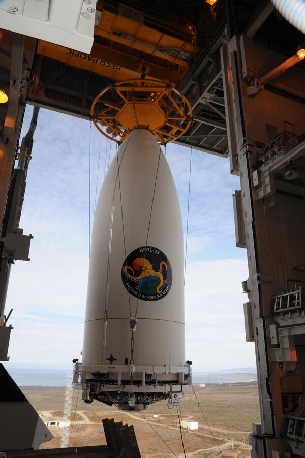
The close-up:

That's got Bond-level villain written all over it.
Let's finish this one off with Jon Stewart justifiably mocking the NSA for its disgusting bravado:
The close-up:
That's got Bond-level villain written all over it.
Let's finish this one off with Jon Stewart justifiably mocking the NSA for its disgusting bravado:
Monday, June 3, 2013

Wednesday, January 30, 2013
Timing
Winter in Foxtrot, by Bill Amend:


Trying to mess with Google Maps satellites (which, for most urban areas in the US, are actually independent companies flying aerial photography that they sell to Google) is a recurring theme in comics recently. Some examples:
Friday, September 28, 2012
Satellite starrys

There are a lot more beautiful satellite shots at NASA and USGS sites.
and an article with embedded videos at Slate.com
Thursday, September 27, 2012
Donald Duck in Mathmagic Land
A couple weeks back we had an excerpt from the animated short The Dot and the Line from that giant in animation Chuck Jones. So here we another giant in animation, Walt Disney, with another math-themed animation with "Donald in Mathmagic Land", a fun and educational film from 1959 that many of you may have seen as a kid. The bit towards the end about sections of a cone ends up showing the globe of the Earth. Here's just that bit:
Many people who saw this in their youth found it inspiring... although many of the aesthetic qualities and other information about the "Golden Ratio" are actually myths. Nevertheless, math is still fascinating and this cartoon demonstrates so very many of the reasons why.
The only place I was able to find the entire video on YouTube had an introductory logo for what appears to be a YouTube channel for a guy who is ...um... keenly interested in numerology and symbology and also a quote from the 1995 movie "Halloween: The Curse of Michael Myers" which, along with the apparently incorrect, information about Walt Disney's Masonry, kinda suggests that the guy who posted it thinks there's something deeply sinister in the cartoon... or maybe he just likes that Halloween movie.
Many people who saw this in their youth found it inspiring... although many of the aesthetic qualities and other information about the "Golden Ratio" are actually myths. Nevertheless, math is still fascinating and this cartoon demonstrates so very many of the reasons why.
The only place I was able to find the entire video on YouTube had an introductory logo for what appears to be a YouTube channel for a guy who is ...um... keenly interested in numerology and symbology and also a quote from the 1995 movie "Halloween: The Curse of Michael Myers" which, along with the apparently incorrect, information about Walt Disney's Masonry, kinda suggests that the guy who posted it thinks there's something deeply sinister in the cartoon... or maybe he just likes that Halloween movie.
Thursday, April 19, 2012
Questionable story arc two-fer
Since we did Thursday's animation on Tuesday we'll do the Tuesday two-fer today. I introduced Questionable Content by J. Jacques. a few months back near the beginning of a space-faring story arc that seems to have now come to a close. The entire rendering was punctuated by increasingly sophisticated spectacular images of the Earth out the space station windows. I'll post the links to the entire story arcs below, but I just want to take a moment to post a few of the more wonderful examples:



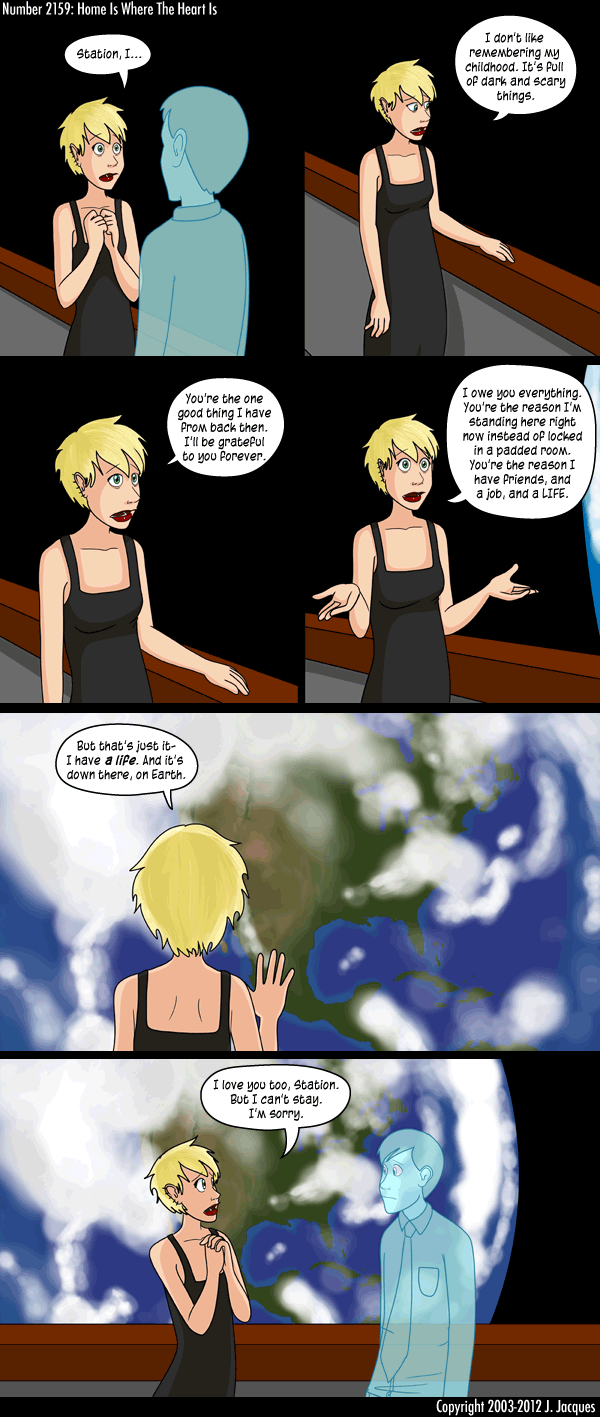
http://questionablecontent.net/view.php?comic=2111: The Space Station
http://questionablecontent.net/view.php?comic=2116: Just a little glimpse
http://questionablecontent.net/view.php?comic=2119: Barely visible through a window
http://questionablecontent.net/view.php?comic=2123: A couple rim shots
http://questionablecontent.net/view.php?comic=2128: Here we go, getting better.
http://questionablecontent.net/view.php?comic=2129: More earthviews
http://questionablecontent.net/view.php?comic=2130: Peeking rims
http://questionablecontent.net/view.php?comic=2131: Barely worth mentioning
http://questionablecontent.net/view.php?comic=2136: Getting the party started
http://questionablecontent.net/view.php?comic=2137: Not much here
http://questionablecontent.net/view.php?comic=2138: Indian Ocean backdrop
http://questionablecontent.net/view.php?comic=2139: The Full Africa!
http://questionablecontent.net/view.php?comic=2140: More Africa
http://questionablecontent.net/view.php?comic=2141: It does kinda look like he's showing a little rotation
http://questionablecontent.net/view.php?comic=2142: Pacific coast
http://questionablecontent.net/view.php?comic=2151: Africa still or again? Gotta be again
http://questionablecontent.net/view.php?comic=2155: Romantic view
http://questionablecontent.net/view.php?comic=2157: More romance
http://questionablecontent.net/view.php?comic=2158: High above the rim
http://questionablecontent.net/view.php?comic=2159: Money shot!
http://questionablecontent.net/view.php?comic=2160: Fall through
http://questionablecontent.net/view.php?comic=2162: Morning after
Wednesday, January 12, 2011
XKCD Height

You're going to have to click on this XKCD by Randall Munroe in order to make it even remotely legible. First scroll all the way to the bottom for the explanation, and then read it carefully all the way up. And read it all you should because there's a LOT packed into this drawing, not just all the little artistic jokes that he threw in there, but also the sheer information of it all (and don't forget to notice the one at the upper right-most corner of the drawing).
This drawing is related to yesterday's because the drawing concept of representing scale logarithmically is somewhat similar, though in this one Munroe made a much more thorough effort at the accuracy of the scale.
Go to this actual webcomic, hover over the image, and there will be an additional message in the "title-text" . This one says:
Now, to be fair, I gotta put this link here in this post, but it'll be even better if you click on it tomorrow...Interestingly, on a true vertical log plot, I think the Eiffel Tower's sides really would be straight lines.
Wednesday, January 5, 2011
Blast off

There are quite a few dog-and-boy comics out there right now:
- Red and Rover of course
- Dog eat Doug (boy is actually a baby who never talks)
- Bleeker: the Rechargable Dog (electronic dog, but still)
- Cow and Boy (different animal, same concept)
- Lio (often does "squid and boy" gags)
- Non Sequitur (if we can count Lio's frequent antics with his squid, we can count Danae's frequent antics with her talking horse... as well as her younger sister's talking dog)
- Calvin & Hobbes (which is, of course the gold standard, now retired, but still available in re-runs)
Wednesday, September 15, 2010
GPS belly button

This is another Over the Hedge by Michael Fry & T. Lewis from November of 2007. For those who may not have guessed, Hammy is a deeply odd character. Hammy masters the GPS quickly and uses it in later adventures.
Friday, September 10, 2010
Ready for my close-up

Tuesday, July 27, 2010

Friday, March 12, 2010
Bad GPS

The GPS technology was initially developed in the 1970's. When the Cold War ended the companies that helped the DoD create it requested that they be allowed to market the technology commercially. The Defense Department finally agreed, but on condition that they could scramble the signal so that nobody could have locations as accurate as the military. So while the military had sub-centimeter-accurate locations, everybody else was limited to locations +/- 30 meters. Within a year of its commercial release some intrepid users had found a way to get around the scrambled signal. After further lobbying the DoD released a more accurate commercial signal, but with a more sophisticated signal scramble so that the commercial devices could be accurate to within 10 meters. Users cracked that signal within 6 months. Finally the military gave up and let the same signal they had out to everybody. They still reserve the right to scramble the signal whenever they deem it necessary, and that could cause this kind of bad behavior. But with the launch of the European "Galileo" GNSS, and the upcoming launch of the Chinese version, what's the point?
Saturday, July 18, 2009
FoxTrot Satellite 6

Google Headquarters actually now sports a massive solar installation. And there are blogs/websites devoted to showing images from Google Earth where people have made specticles specifically for aerial viewing, if not directed at Google Earth itself. All the world has become a stage.
Friday, July 17, 2009

Thursday, July 16, 2009
FoxTrot Satellite 4

Did Mr. Amend know at the time he did the satellite imagery week that Dick Cheney had ordered the Vice President's address to be blurred out on Google Earth and other satellite imagery sites? Or was that too easy a target?
If anybody out there still harbors any illusions about Dick Cheney not being a profoundly troubling individual, take this recent quote from him about Gitmo detainees: "...if you don't have a place where you can hold these people, your only other option is to kill them."
Wednesday, July 15, 2009
FoxTrot Satellite 3

Definitely echoes from the early 2000's. The second 3 Star Wars movies definitely got a bad rap. I personally liked them well enough. But I don't know that they ever could have lived up to the originals. Jar-Jar was jarring, sure. And the holes in the plots were large enough to walk an At-At through (Why in the world couldn't the Jedis have simply gone back and freed Anakin's mother from a life in slavery? Wouldn't that have dramitically mitigated Anakin's evil streak?). But then again the original 3 were campy and flawed in their own right. But tremendously ground-breaking and iconic. Star Wars will always be a landmark in cinematic and cultural history, for good or ill.
Tuesday, July 14, 2009
FoxTrot Satellite 2

Actually it is possible to see people on Google Earth, but that's rarely from the satellite imagery. Most cities in the US are covered by aerial photography that is higer resolution than the satellite imagery. And there are plenty of people who troll Google Earth looking for people on nude beaches. But there's never much to see. And Google itself tries to remove such images. Whtcha gonna do.
Subscribe to:
Posts (Atom)