Showing posts with label war. Show all posts

Saturday, February 28, 2015

Saturday, January 17, 2015

Great Battles

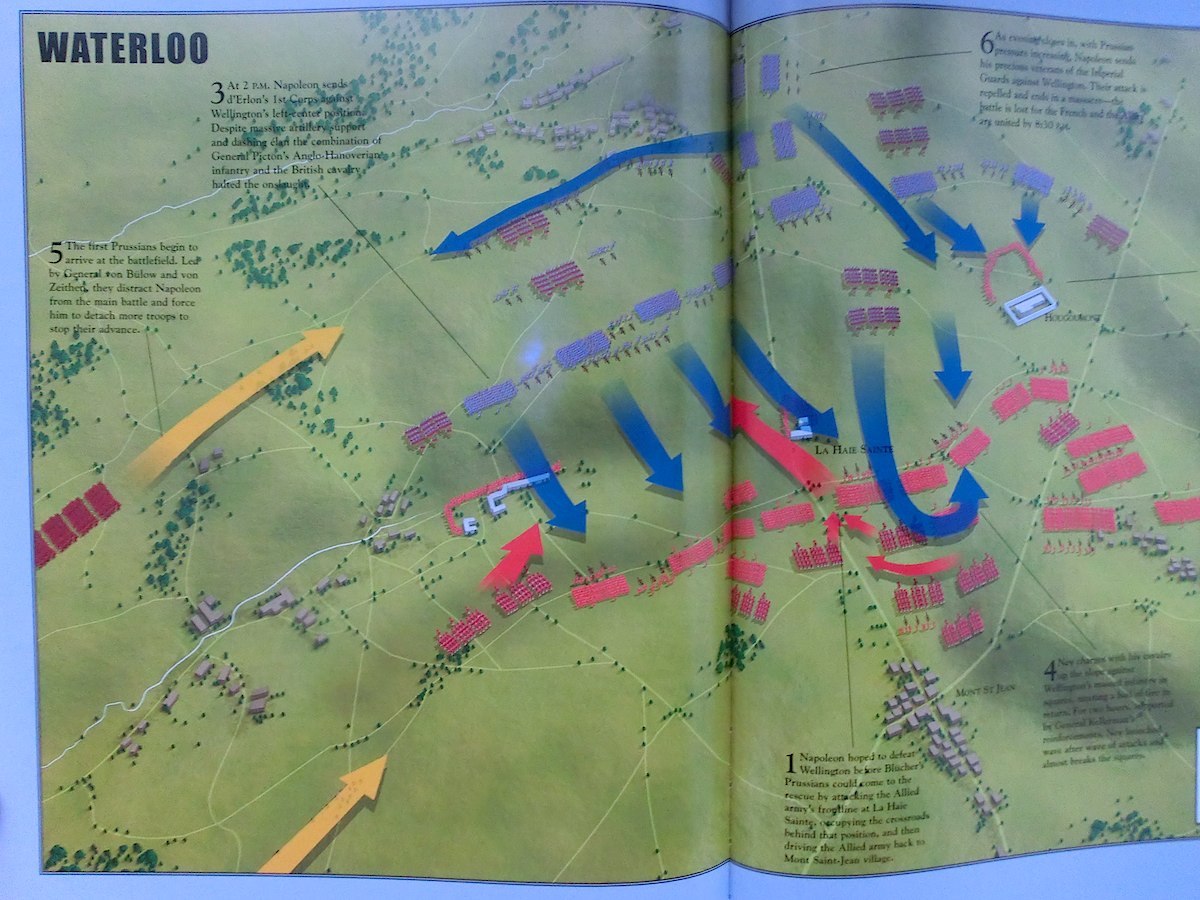
Would you like a book that elegantly diagrams and explains great battles throughout history?  Of course you would.  Get it over at Winkbooks
Great Battles – Covering 30 important battles of the western worldGreat Battlesby Christopher JorgensenParragon Inc2007, 256 pages, 9.6 x 11.8 inchesFrom $4 Buy a copy on Amazon
A selection of 30 of the most important battles of the western world, from the ancient Greeks to more contemporary conflicts, organized chronologically into three sections (Age of Sword, Age of Gunpowder and Age of the Rifle). Each battle spreads across eight pages, the first six including an account of the battle, illustrations and some side texts. The last two pages covering each battle are always the most interesting, depicting a two-page colorful map of the battlefield showing the troops’ positions, directions of movements and important terrain features.  – Alessandro Nicoli de MattosJanuary 15, 2015
 

Monday, September 29, 2014

Khartoons (guest post)

Amanda Murphyao here derailing your regularly schedule Monday morning world map cartoons with some of Khalid Albaih's "Khartoons" from Aljazeera:


Tuesday, June 17, 2014

Scott's great snake

Let's stick with the Civil War-era editorial cartoons as a weekly feature for a while.  Here's one that depicts a plan for a 3,500-mile-long Union blockade of Confederate shores and ports as a constricting anaconda.  The "Scott" in the title is Winfield Scott who was the commanding officer of Federal troops at the start of the Civil War.  Lincoln chose a direct attack on Virginia rather than Scott's slower blockade plan, but that resulted in defeat.  By Fall of 1861 Scott resigned and was replaced by McClellan.

Wednesday, June 4, 2014

Nast-y retreat

This woodcut map appeared in the November 10, 1877 issue of Harper's Weekly.  It was drawn by the famous political cartoonist Thomas Nast. Titled "Map of N. Jersey", it is done after the style of Revolutionary War military maps, but also in the style of patterns for making clothes which were a regular feature in Harper's Bazaar magazines... thus the sub-caption: “ 'Little Mac's' Plans in Case of Defeat. N.R. – Ladies will please not take this for a Bazaar 'Pull-Back' Pattern.” "Little Mac" is General George McClellan, the initial commander of Union forces at the start of the Civil War, who is credited by some, including Nast, as having very badly mis-managed the Union war efforts, who ran against and lost badly to Abe Lincoln in the 1864 elections, and who Thomas nast regularly lambasted for years afterwards.
Friday, May 9, 2014

Insurgency Tracker

Friend-of-the-blog Rob has submitted the Invisible Armies Insurgency Tracker which an interactive mapping tool that looks at a database of insurgencies from 1775 to 2012. It goes with the book Invisible Armies: An Epic History of Guerrilla Warfare from Ancient Times to the Present, by Max Boot.


Thursday, January 30, 2014

Humans dehumanizing humans

Ah, good old de-humanizing propaganda.  And with maps there's even less subtlety! Here's a pair of WWII-era propaganda images from either side of the conflict from an article in New Scientist about humans dehumanizing each other.

This is the French Vichy state showing what's supposed to be Churchill-as-octopus... because octopus is geographer shorthhand for global domination.
Translation: "Be assured, the amputations are proceeding methodically."

Wednesday, January 29, 2014

Monday, January 27, 2014

Another fuse is lit (guest post)

Hello! Guest contributor Amanda Murphyao here. I'm putting up historical cartoons involving the world or globe from the United States Library of Congress for the next few Mondays.


Duffy - The keeper of the light of Asia - 1950-3

Friday, October 11, 2013

WWII European Theater in 7 minutes

This is neat. It's even neater cosidering the guy did it with Microsoft Paint:

We've seen things like this before

Saturday, October 5, 2013

Zero gets a promotion?

Here's one form Mort Walker's Beetle Bailey that's just chock-full of the map.  I'm not interested enough in this comic to follow it long enough to find out whether Zero's promotion is permanent.


Monday, July 15, 2013

American Advance

This submission by Amanda is a WWII-era cartoon by Frank Duggan entitled "American Advance".

M2001.74.109


Saturday, May 18, 2013

From above

A few weeks back there was a post from a Saturday Morning Breakfast Cereal webcomic by Zach Weiner that included a from-underneath shot of Antarctica. This time he used a from-above view of the north pole (panels 9 & 10).  Still ends in disaster.  Here's a link to a larger version of it.


Monday, May 13, 2013

Pair of Uncle Sams

Here's a pair of Uncle Sam themed maps in comics from Amanda.  The first is from Aislin (alias Terry Mosher) from about 2002.  The second is from John Collins from about 1953.


Wednesday, March 6, 2013

Bloody Balkins


The New Yorker magazine regular Michael Crawford is no stranger to using maps in his comics.  This is a depiction of a blood-soaked Balkins region during the bloodshed there in the 1990s.

Friday, July 27, 2012

Iran wants war?

Here's one more item from Amanda. This one is in a vein similar to the item she submitted earlier about isolationism, although this one arguably takes an opposing point of view, or one that is closer to the Nazi propaganda map if one wants to invoke Godwin's Law and compare Iran to the Nazis.

I do sincerely hope more war in that region is avoidable.  However the combined effects of the U.S. involvement in Iraq, Afghanistan, and Pakistan, along with the fallout from various "Arab Spring" events is already dramatically altering the geopolitical stage in that region.

Tuesday, July 3, 2012

Isolationist two-fer

Today's two-fer is a pair of pre-WWII pieces.  The first one is from Amanda, who sent us yesterday's item and a bunch of others.  This is from 1938 from the famous political cartoonist Herblock who here is making the case against the pre-war isolationism that was quite thoroughly prominent in the U.S. before the war (the hard-to-read caption says "Is this what you mean?")

The second item originally ran in U.S. publications and came from the Nazis in an attempt to support that isolationism.  This illustration was re-published in the book How To Lie With Maps by Mark Monmonier as a prime example of propagandistic maps:

Extra points to anybody who can name all those landmasses on the right.