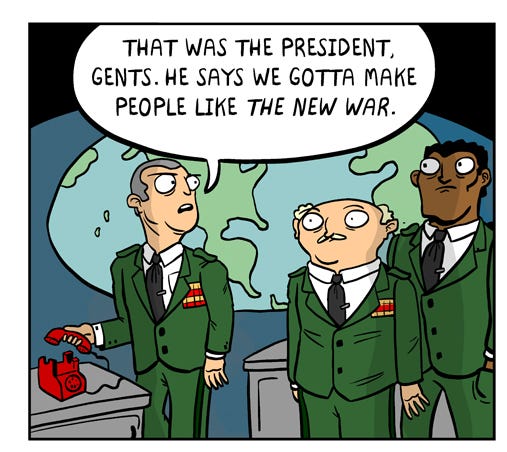
Here's three panels from a strip on The Nib by Matt Lubchansky. The rest of the strip is here.
Saturday, February 28, 2015
This memes war
Labels:
Blue Sky GIS,
Matt Lubchansky,
meme,
soldier,
The Nib,
war,
war map,
war room
Friday, February 27, 2015
Do you know what you know?
BuzzFeed gives a great video about issues that can arise from casual geographic education:
Labels:
Blue Sky GIS,
Buzzfeed,
education,
geography,
map animation
Thursday, February 26, 2015
Dog's world
One of the slides in this animated GIF slideshow from College Humor shows how dog's think of the planet:
Labels:
Blue Sky GIS,
College Humor,
dog,
Earth,
globe,
toilet,
view
Wednesday, February 25, 2015
Introducing Camp Weedonwantcha
Camp Weedonwantcha, by Katie Rice is a brilliant little webcomic about a batch of kids stranded at an endless summer camp. It would appear that they may be starting a new map-based story arc.
Labels:
Blue Sky GIS,
camp,
Camp Weedonwantcha,
katie Rice,
lake,
map,
webcomic
Tuesday, February 24, 2015
Spidey tracker
Did you know that Spiderman encountered GPS tracking devices in 1977? Well, ok, it was actually an "electronic radar device". Still, what a nifty idea! Maybe that's how Spiderman figured out how to make a tracking device better than GPS.
Labels:
Blue Sky GIS,
comic strips,
GPS,
Spiderman,
Stan Lee,
super heroes,
tracking
Monday, February 23, 2015
Even More Historical Caricatures!
During
some research, I came across a collection of caricature anthologies that
feature "great men" from various geographic areas. Many of the
caricatures from these collections included globes.
Here
we have John B. Murphy on page 101 of Chicagoans As We See 'Em, circa 1904:
- Amanda Murphyao
Labels:
1904,
as we see 'em,
Chicago,
globe,
historical caricatures,
world
Sunday, February 22, 2015
GPS the bears
Jack Elrod's Mark Trail recently mentions GPS in a Sunday strip that serves up some rather alarming information about bears.
Labels:
bears,
Blue Sky GIS,
GPS,
Jack Elrod,
Mark Trail
Saturday, February 21, 2015
Colored orientation
This is a bunch of city maps by Stephen Von Worley showing streets colored according to orientation:
San Francisco |
London |
Tokyo |
New York |
Labels:
Blue Sky GIS,
cartography,
city,
orienteering,
Stephen Von Worley
Friday, February 20, 2015
Möbius GPS
Labels:
Blue Sky GIS,
car,
directions,
GPS,
Michael Maslin,
navigation,
The New Yorker
Thursday, February 19, 2015
International Breakfast
What happens when a bunch of Yankee kids are asked to try out breakfast foods from around the world? The folks at Cut Video decided to find out.
Wednesday, February 18, 2015
Dungeon projection
Redditor silverlight used a video projector to make an impresseive D&D gameplay experience
Tuesday, February 17, 2015
Five Oceans (not to be confused with Seven Seas)
Friend-of-blog Susan has contributed this item that was new information for me: The Southern Ocean is the world's 5th ocean, where previously there had only been 4 defined, and it was only officially defined by the International Hydrographic Organization in 2000.
I already knew about the 5 oceans, but I hadn't realized The Southern Ocean's designation was so recent. I'll admit that when I was smaller I was very confused about mentions of The Seven Seas in pirate stories and my inability to match that with an equal number of oceans on the National Geographic world map that was in our family's dining room. Then I figured that The Seven Seas weren't referring to oceans, but rather to smaller bodies of water that Pirates frequented in the Golden Age of piracy... but I never bothered to learn what those Seven Seas were supposed to be.
Turns out that's not right either. The Seven Seas did, in fact, refer to all the world's oceans... as they were known as early as Ancient Sumeria some 4300 years ago. The number 7 of them was used to match up with astrology, there being 7 known planets (until somebody found Neptune in the 1700s).
Medieval Arabian literature identifies the Seven Seas as the Persian Gulf ("Sea of Fars"), the Gulf of Aden ("Sea of Larwi"), the Bay of Bengal ("Sea of Harkand"), the Strait of Malacca ("Sea of Kalah"), the Singapore Strait ("Sea of Salahit"), the Gulf of Thailand ("Sea of Kardanj"), and the South China Sea ("Sea of Sanji").
But Medieval Arabian literature also referenced other Seven Seas:
The Black Sea
The Caspian Sea
The Arabian Sea
The Indian Ocean
The Red Sea
The Mediterranean Sea
The Adriatic Sea
Medieval European literature referenced a somewhat different list of Seven Seas:
The Adriatic Sea
The Mediterranean Sea, including its marginal seas, notably the Aegean Sea.
The Black Sea
The Caspian Sea
The Persian Gulf
The Arabian Sea (which is part of the Indian Ocean)
The Red Sea, including the closed Dead Sea and the Sea of Galilee
And sometimes the list included a few others:
The Atlantic Ocean
The Aegean Sea
The Indian Ocean
The North Sea
So the Seven Seas hasn't had much significance for several hundred years at least.
Monday, February 16, 2015
First Partition of Poland
I could've sworn this one has shown up on the blog before, but I can't find it when Amanda sent it to me. This is The Allegory of the First Partition of Poland by Noël Le Mire:
It's after The Troelfth Cake, a 1773 French allegory by Jean-Michel Moreau le Jeune and there have been a number of versions of this rather iconic early political cartoon:
Labels:
Blue Sky GIS,
Europe,
history,
Jean-Michel Moreau le Jeune,
Noël Le Mire,
Poland
Sunday, February 15, 2015
Clean out the fridge!
Last month we had a comic from Twistedspeedo by Henrik Tomenius. Here's another:
Labels:
angel,
Blue Sky GIS,
clouds,
evolution,
Henrik Tomenius,
mold,
refrigerator,
Twistedspeedo,
wings
Saturday, February 14, 2015
Cupid's weather map
Here's a map and a poem from 1907
Friday, February 13, 2015
Don't mess with it
Well of course that's what the biggest BBQ in the world is going to look like:
Thursday, February 12, 2015
Wednesday, February 11, 2015
And in weather, iron boils
This is what you do when your weather map goes into open rebellion:
Tuesday, February 10, 2015
Directionally challenged
A while ago Buzzfeed had a listicle about 25 problems all directionally-challenged people can relate to (click for the full list). Even some of us directionally-taleneted can relate to some of these.
5. When not being able to find your car in the parking lot becomes a regular occurrence.
Monday, February 9, 2015
More Historical Caricatures!
During
some recent research, I came across a collection of caricature anthologies that
feature "great men" from various geographic areas. Many of the
caricatures from these collections included globes.
Here
we have T. P. Cook and E. J. Nally on page 73 of Chicagoans As We See 'Em, circa 1904:
(The image was a bit blurry so I tried to get cleaner shots of the globes.)
- Amanda Murphyao
Labels:
1904,
as we see 'em,
Chicago,
globe,
historical caricatures,
world
Sunday, February 8, 2015
Sea monster sculptures
So remember the post we did a while ago about Olaus Magnus’ 1539 Carta Marina, that alsmot iconic maps of the world that featured crazy sea monsters? Artist Bailey Henderson has made some sculptures out of some of those:
Labels:
artists,
Bailey Henderson,
Blue Sky GIS,
cartography,
monster,
sculpture
Saturday, February 7, 2015
Open Street Maps clothes
Do you need an article of clothing that shows a location that you like? Monochrome will produce exactly that for you from Open Street Maps data
Friday, February 6, 2015
View from Above game
This is probably just a marketing gimmick, but it's kinda fun to play the game: look at the aerial photo and guess where it is on the planet.
Thursday, February 5, 2015
Chip and stans
I want to give kudos to Hi & Lois for a geography joke... but there are, in fact, only the five ex-Soviet Central Asian countries Chip mentioned... although how a typical US high school student would even be asked this, much less know it, is far fetched.... except that Chip was studying for this moment back in 2009. Maybe she has a 25-year-old paper map on the wall and the students are looking up more current geographic info on the interwebs? If she's looking for Armenia or Azerbaijan she's got to take both, not just the one... and seriously consider Georgia. If she's just punking them then it's a lame punk.
Labels:
Blue Sky GIS,
Brian Walker,
Central Asia,
Chance Browne,
geography,
Hi n Lois,
high school,
Kazakhstan,
Kyrgyzstan,
school,
stans,
Tajikistan,
teacher,
Turkmenistan,
Uzbekistan
Wednesday, February 4, 2015
Remember last week's massive snow storm? Joe Dator had a New Yorker comic about it.
Labels:
Instafram,
Joe Dator,
snow,
The New Yorker,
weather,
weather map
Tuesday, February 3, 2015
Seward's Folly
Considering that Alaska wasn't even a US territory at the time, this is an impressively wrong factoid.
Monday, February 2, 2015
More Historical Caricatures!
During
some recent research, I came across a collection of caricature anthologies that
feature "great men" from various geographic areas. Many of the
caricatures from these collections included globes.
Here
we have M.J. Carpenter on page 23 of Chicagoans As We See 'Em, circa 1904:
- Amanda Murphyao
Labels:
1904,
as we see 'em,
Chicago,
globe,
historical caricatures,
world
Sunday, February 1, 2015
Morning news
I try very hard not to expose myself to TV news, and morning news shows seem to be an especially virulently vapid flavor of the form. Still, I suspect that this assessment by Francesco Marciuliano's Medium Large strip of the typical morning show's daily descent into aggressive idiocy is accurate. I'd ask if anybody out there can verify, but I'd worry too much for your mental health if you can/did.
Labels:
Blue Sky GIS,
comic strips,
earthquake,
Francesco Marciuliano,
island,
Medium Large,
TV news
Subscribe to:
Posts (Atom)