
Friday, February 28, 2014
It might get better. Oh no!
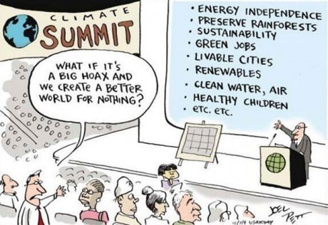
This sums up a very important point against climate change denial... although the typical reducto ad absurdum response tends to be that the environmental solution requires eliminating technology, not making the technology better.


Thursday, February 27, 2014
Introducing Table Titans
We've seen Scott Kurtz outstanding Player vs. Player webcomic. Here's an episode of his people-playing-D&D webcomic, Table Titans. Enjoy
Wednesday, February 26, 2014
Anime 1988

Tuesday, February 25, 2014
Monday, February 24, 2014
Wood 3 (guest post)
Hello! Guest contributor Amanda Murphyao here. I'm putting up historical cartoons involving the world or globe from the United States Library of Congress for the next few Mondays.


Art Wood - Wearing Kinda Thin - 13 Oct 1955
Sunday, February 23, 2014

Saturday, February 22, 2014
Better dead than red
In this episode of Gil Thorp by Neal Rubin and Rod Whigham some random character teaches the students more geography in a hallway moment than they'll ever see in class.

Friday, February 21, 2014
GPS AA
Moondog, here in Jim Meddick's Monty, has woken from a drunken stupor to get his bearings. Binge drinking is so funny.

Thursday, February 20, 2014

Wednesday, February 19, 2014
Transpacific Partnership agreement explained
Here's a map-infused cartoon about the Transpacific Partnership agreement that some are trying to "fast track" through Congress. It's from the guys who wrote Economix, a terrific cartoon history of economics by Michael Goodwin and illustrated by Dan E. Burr. It's a long read, but an enlightening one.
Page one:

Page one:
Tuesday, February 18, 2014
Tonight at 11
Dan Rosandich gives us this grim... and I think kinda tired... take on tv news. The blob on the front of the news desk is probably a sloppy attempt at a Goode's Homolosine Equal Area Projection

Monday, February 17, 2014
Wood 2 (guest post)
Hello! Guest contributor Amanda Murphyao here. I'm putting up historical cartoons involving the world or globe from the United States Library of Congress for the next few Mondays.


Wood - Contagious - 26 July 1955
Sunday, February 16, 2014
Gravity well
There simply is an endless supply of map-ish xkcds by Randall Munroe. this one does a beautiful job of illustrating gravity wells. The "title-text" at the actual webcomic says:

This doesn't take into account the energy imparted by orbital motion (or gravity assists or the Oberth effect) all of which can make it easier to reach outer planets.
Click on the image to enlargify.
Saturday, February 15, 2014
Map of a woman's heart
"The Open Country of Woman’s Heart, Exhibiting its internal
communications, and the facilities and dangers to Travellers therein”
(1830s), by D.W. Kellog.

Friday, February 14, 2014
Burn down the whole world
Remember our friend Claire Fontaine and her mapstick art? Italy, France, and even the good ol' US of A wasn't enough for her. She wanted to burn down the world. And here she does (at least I'm assuming it's her... might not be). 
Thursday, February 13, 2014
Back handed
Here in Herb and Jamaal by Stephen Bentley our heroes are resorting to an old-fashioned paper map ... which makes a kind of sense given their arguably old-timey vehicle and hats. But seriously, who memorizes the back of their hand?
Wednesday, February 12, 2014
Olympic odds
ASAP Science is putting out an Olympics-themed video every day of the Olympics. This one is front-end-loads a pile of anthropomorphized country maps and discusses the odds of becoming a winter Olympian
Tuesday, February 11, 2014
The first Lego movie
This is a movie from 1973 made by Lars and Henrik Hassing, the two cousins who were 12 and 10 at the time. It may be the oldest Lego movie. At 2:00 and 4:39 the boys used a globe to portray the space travel away from and back to Earth.
Monday, February 10, 2014
Wood 1 (Guest post)
Hello! Guest contributor Amanda Murphyao here. I'm putting up historical cartoons involving the world or globe from the United States Library of Congress for the next few Mondays.


Wood - Squeeze Play - 1950
Sunday, February 9, 2014
Lewis and Cluck: Explorer Chickens
Here's an item from the webcomic Lewis and Cluck: Explorer Chickens by Bill Rilling. Given that they're globe-trotting, explorer chickens, they're frequently mappy.... but is it frequently funny?:

Saturday, February 8, 2014
United States of GDP
Created by Reddit user Phaenthi, this map presents U.S. states and corresponding countries with similar GDP.
Friday, February 7, 2014
Globes
Here's a tantalizing preview of The Art and History of Globes, a massive, gorgeous art-book tracing the history of globes. Written by Sylvia Sumira


Thursday, February 6, 2014
Wednesday, February 5, 2014
Most detailed yet map of the Internet
There have been several other posts about maps of the internet (1, 2, 3). This is a screenshot of the most detailed attempt yet, from Slovakian artist named Martin Vargic. Go to the link and click on the map to experience the full interactive, zoomable, pan-able experience.

Tuesday, February 4, 2014
Rejects
Here's a completely unrelated pair of geography comics published decades apart:
 |
| Reality Check by Dave Whamond |
 |
| Charles Addams from The New Yorker in 1936 |
Monday, February 3, 2014
All hail the queen (guest post)
Hello! Guest contributor Amanda Murphyao here. I'm putting up historical cartoons involving the world or globe from the United States Library of Congress for the next few Mondays.


Rosen - Big day a comin - c June 1953
Sunday, February 2, 2014

Saturday, February 1, 2014
Fantasy maps
The New Yorker has an article by Casey N. Cep about maps in fantasy stories. Here's some of the maps from the article:
 |
| Map of Treasure Island, from Robert Louis Stevenson’s “Treasure Island.” |
 |
| Illustration by Roland Chambers, from Lev Grossman’s “The Magicians.” |
 |
| Illustration by Roland Chambers, from Lev Grossman’s “The Magician King.” |
Friday, January 31, 2014

Thursday, January 30, 2014
Humans dehumanizing humans
Ah, good old de-humanizing propaganda. And with maps there's even less subtlety! Here's a pair of WWII-era propaganda images from either side of the conflict from an article in New Scientist about humans dehumanizing each other.

This is the French Vichy state showing what's supposed to be Churchill-as-octopus... because octopus is geographer shorthhand for global domination.
This is the French Vichy state showing what's supposed to be Churchill-as-octopus... because octopus is geographer shorthhand for global domination.
 |
| Translation: "Be assured, the amputations are proceeding methodically." |
Wednesday, January 29, 2014
Tuesday, January 28, 2014
Monday, January 27, 2014
Another fuse is lit (guest post)
Hello! Guest contributor Amanda Murphyao here. I'm putting up historical cartoons involving the world or globe from the United States Library of Congress for the next few Mondays.


Duffy - The keeper of the light of Asia - 1950-3
Sunday, January 26, 2014
Saturday, January 25, 2014
Smiley Face Germany (guest post)
Here's a panel from SMBC that doesn't include the image, but does mention the shape of a map:

(Image links to source.)
Friday, January 24, 2014
Lost on the moon
Here's the debut of Invisible Bread by Justin Boyd on our blog with a guy who is very lost.

But not the first time this particular joke has appeared on this blog:
Driving to the moon
And again
Lunar jailbreak
But not the first time this particular joke has appeared on this blog:
Driving to the moon
And again
Lunar jailbreak
Thursday, January 23, 2014
Wednesday, January 22, 2014
XKCD's Actually
xkcd by Randall Munroe that touches on a fundamental concept behind geodetics. The "title-text" at the actual webcomic says:

Protip: You can win every exchange just by being one level more precise than whoever talked last. Eventually, you'll defeat all conversational opponents and stand alone.
Tuesday, January 21, 2014
Monday, January 20, 2014
Global defense (guest post)
Hello! Guest contributor Amanda Murphyao here. I'm putting up historical cartoons involving the world or globe from the United States Library of Congress for the next few Mondays.


Fischetti - Now keep your fingers crossed - 1953
Sunday, January 19, 2014
Saturday, January 18, 2014
Friday, January 17, 2014

Thursday, January 16, 2014
When you wish
In this Saturday Morning Breakfast Cereal webcomic artist Zach Weiner reminds me of a passage from The Hitchhiker's Guide to the Galaxy:


Eventually of course, after their Galaxy had been decimated over a few thousand years, it was realized that the whole thing had been a ghastly mistake, and so the two opposing battle fleets settled their few remaining differences in order to launch a joint attack on our own Galaxy --- now positively identified as the source of the offending remark.
For thousands more years the mighty ships tore across the empty wastes of space and finally dived screaming on to the first planet they came across --- which happened to be the Earth --- where due to a terrible miscalculation of scale the entire battle fleet was accidentally swallowed by a small dog.
Wednesday, January 15, 2014

Subscribe to:
Posts (Atom)