Tuesday, July 31, 2012

The New Yorker: GPS two-fer

Here are 3 GPS-themed cartoons from The New Yorker:
Dean Vietor from August 2001
Roz Chast with 3 cards for GPS devices:

#1: When I'm driving in my car
You always know just where we are
You're never mean, you're always nice
My darling GPS device
How did I live without you?

#2 You and I are quite a pair
Together we drive everywhere!
Up to Alaska, down to Peru
Just like other people do!
Let's never be apart

#3 Roses are red, turtles are slow,
I'll go however you want me to go.
I trust your judgement implicitly.
William Haefeli from May 2000

Monday, July 30, 2012

We're not in Mrs. Feldman anymore, Toto

I think we might do a New Yorker theme this week.  Here's one by Paul Noth from April of 2009.

I remember talking with some GIS professionals back in the mid-1990's who were working on a geodesy for the human body that could be the basis for individualized projections in a GIS.  I wonder what became of that project: Medical GIS.

Friday, July 27, 2012

Iran wants war?

Here's one more item from Amanda. This one is in a vein similar to the item she submitted earlier about isolationism, although this one arguably takes an opposing point of view, or one that is closer to the Nazi propaganda map if one wants to invoke Godwin's Law and compare Iran to the Nazis.

I do sincerely hope more war in that region is avoidable.  However the combined effects of the U.S. involvement in Iraq, Afghanistan, and Pakistan, along with the fallout from various "Arab Spring" events is already dramatically altering the geopolitical stage in that region.

Thursday, July 26, 2012

Melvin the Machine

The rest of the week has involved a lot of heavier political topics. Today we'll do something light-hearted. A nicely edited video about a portable rube goldberg machine that for some random reason starts with a map: "Melvin the Machine"
Melvin the Mini Machine from HEYHEYHEY on Vimeo.

Wednesday, July 25, 2012

Rush transit

We've been on a politcal cartoon kick so far this week, I figure we can handle another.  This one is Tom Toles poking fun at the D.C.-area transit system. I would have put it up with the transit two-fer round up a few months ago, but it was published after that.

Tuesday, July 24, 2012

Bloody Syria two-fer

With conditions in Syria becoming quite thoroughly out of control, here's a round-up of map-of-Syria-based editorial cartoons, mostly from cartoonists in the Middle East (and don't forget the "Why so Syria" t-shirt):
Emad Hajjaj

Hassan Bleibel

This one doesn't use a map of Syria, but rather a globe showing the general area of the Middle East:
Manny Francisco
Am I the only one who think's Assad's neck is freakishly long?
Manny Francisco

Oliver Schopf
I'm pretty sure that burning bus is supposed to be in the shape of Syria. I think this one gets the award for most creative use of the shape of Syria.
Hassan Bleibel

Steve Sack

Chris Grosz


Ena Bockel

Monday, July 23, 2012

Florida political weather


With the political campaigns in full swing we can throw up as many map-based editorial cartoons as you'd like.  In this one by Jim Morin we have Romney-as-weatherman keeping Florida Governor Rick Scott in check, a reference to Scott's comments about how Obama's policies have helped his state.

Friday, July 20, 2012

Middle Earth Dress

We're assembling quite the collection of map apparel on the blog.  We've had the boot made from a map of Italy (duh), and a Napoleonic hat map, not to mention all the t-shirts with funny map-related jokes. Today we have a map-based dress... but not just any map.  This may be the world's most recognizable, if not beloved, map of a fictional place.  I give you: The Middle Earth Dress:

That'd look great with the Italy-map boots and the map hat, dontcha thin?. It's available at Fashionablygeek.com.  Please limit your comments about "exploring the plains of Harondor".

Thursday, July 19, 2012

Thank you magnetoshpere!

Here's a fun video from NASA that starts with a fascinating visualization of how Earth's magnetosphere protects us from frequent coronal mass ejections (CMEs) from the sun, and then moves on to the "Dynamic Earth" ocean visualization I posted a couple months ago (that video embed link works now). Venus, which has no magnetosphere, gets fairly thoroughly pummeled before the simulated CME reached Earth.  That'll be an important problem to overcome when humans eventually decide to make Venus habitable.


Wednesday, July 18, 2012

Beautiful Akron!

Here's another item from Amanda.  This one is very like these others on the same theme that we posted last Fall. 

Tuesday, July 17, 2012

California blues two-fer

Here's a batch of editorial cartoons about California's various woes, mostly financial.


Michael Ramirez comparing California to Greece's financial ills.  Honestly California is not as bad as that. And in truth Greece remains wealthier than most nations on the planet... both that's all cold comfort to those who are suffering.


The next three are by Steve Breen, debuting on the blog.  I'll take issue with this critique as well: If California is such an oppressively difficult state in which to start or do business, why does Silicon Valley remain there and, frankly, thriving? But that's just one industry sector.  I'm sure none of the other industries in the state are doing any good.


And the worst for last. Yeah, it's effectively the same joke that Ramirez made, but Mr. Asay's work tends to be rather venomously odious. This one's fairly mild.


Monday, July 16, 2012

Charlie Brown's camp map

Today's post again comes from Amanda and is perfectly suited for this Summer season. It's Charlie Brown in front of a map of his summer camp. I remember the Charlie Brown summer camp TV special very fondly from my youth. I remember finding it quite suspenseful... although I don't think this image is actually from that episode.  But go ahead and check it out for yourself since I've embedded the video for that classic cartoon below.


Friday, July 13, 2012

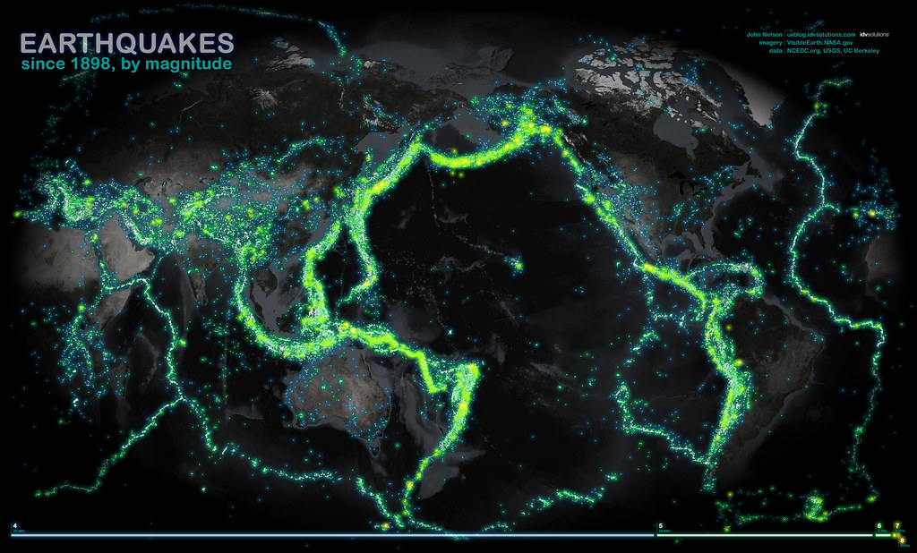
ALL THE EARTHQUAKES!


An image of a plot of all the  earthquakes from 1898 through 2003.  Created by data visualizer John Nelson (Flickr link)


Thursday, July 12, 2012

Build the Lego world

Here's a treat for animated map Thursday: Google and Lego have released a new tool called "Build" that allows users to pick a place on the planet and build something there with Legos. It's a virtual environment, and the brick choices are a tad limited.... and it only works for Australia and New Zealand for now. But neat, eh?

Wednesday, July 11, 2012

So stupid

Here's another cartoon from Amanda, this one about the state of geography education among these kids today.

There have been quite a few on that theme:

Hungary games
Epic South Carolina fail
Yard sign
Little girl
South America

Also, I'm going to count this as the debut appearance of Vermont, bringing our total of states specifically mentioned in cartoons on the blog to 35.

Tuesday, July 10, 2012

QR code Two-fer

QR codes!
We've all seen 'em. I'm not sure that we all like 'em. And they all kinda look like malformed  crossword puzzles. 

Some businesses put them on their roofs.... so that ...astronauts can scan them?

Here's the Facebook HQ QR code:


Here's the roof of Phillips & Company... I have no idea what they do, but one could scan the QR code and find out!


However I have to agree with Dave Kellet's Arthur-the-duck in Sheldon about how QR codes seem like a transition technology.... kinda nifty, but in the end off-putting and/or clunky.

And as a bonus, here's a not-map-related-but-still-fun video about how a South Korean company boosted sales with an innovative sundial QR Code:

Monday, July 9, 2012

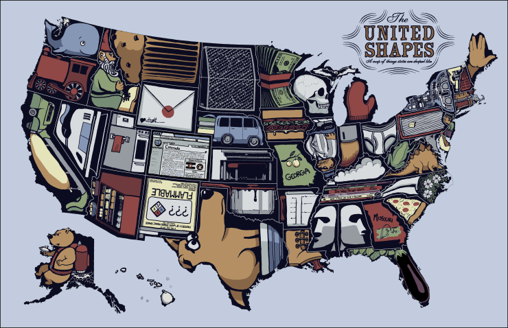
XKCD's United Shapes


Most of the time I try to space out examples of maps in comics from Randall Munroe's XKCD because there are so many that I could devote an entire month to just those and then everybody'd get sick of them.

But today's XKCD is simply  begging to be highlighted on today's post.  I mean COME ON!

At the actual webcomic, hovering over the image reveals this additional message in the "title-text":
"The eggplant is in something of a flaccid state."

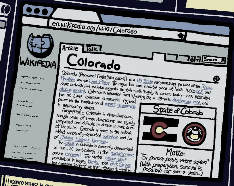
Also, do check out the side-splitting hilarity that is the detail on the Wikipedia article lampooned in Colorado:

Thursday, July 5, 2012

Invader Zim

For today's animation Thursday we bring you Invader Zim!, an excellent animated series that aired on Nickelodeon in the early and mid naughties.  First we have a photo of a devoted fan who commissioned a tattoo:

And then there's an example of the series' excellence with the episode "Planet Jackers" which showcases various globes, including Earth:

InvaderZIM - Episode 12 - Planet Jackers [part 1]

Wednesday, July 4, 2012

Happy Texmexamericanadia Day!

This one is from Amanda also and was authored by Graeme MacKay, a Canadian editorial cartoonist. It's from a few years ago and seems to be presenting to the Canadian Prime Minister some plan for unifying the largest nations of North America. This is a nightmarish concept for many people in the conservative parts of the U.S. political arena and was rolled out as a particularly fearsome ghoul under Bush I's term and NAFTA.  That's obviously George W. Bush and Vicente Fox representing the USA and Mexico respectively. I'm sorry, but I can't tell if that's supposed to be Paul Martin or Stephen Harper there as Canada's prime minister. 


Tuesday, July 3, 2012

Isolationist two-fer

Today's two-fer is a pair of pre-WWII pieces.  The first one is from Amanda, who sent us yesterday's item and a bunch of others.  This is from 1938 from the famous political cartoonist Herblock who here is making the case against the pre-war isolationism that was quite thoroughly prominent in the U.S. before the war (the hard-to-read caption says "Is this what you mean?")

The second item originally ran in U.S. publications and came from the Nazis in an attempt to support that isolationism.  This illustration was re-published in the book How To Lie With Maps by Mark Monmonier as a prime example of propagandistic maps:

Extra points to anybody who can name all those landmasses on the right.

Monday, July 2, 2012

Wonder-ful

A few weeks ago Amanda sent us a comic with an anthropomorphized map of South Africa.  Last week she sent a large batch of comics with maps in them that we'll be posting over the next few weeks.  We'll start with this item about how the ancient world works from a Wonder Woman comic book:

That seems like a very small world. It doesn't cover even a tiny fraction of the area conquered by the Greeks who these gods depicted had jurisdiction over.

Thanks Amanda!