Wednesday, July 31, 2013
North Dakota teaches democracy to the rest of us
North Dakota! That pioneering leader in the concept of democracy. Amanda gives us this inspirational editorial cartoon about the northernmost Dakota. 46 down, 4 to go:

Tuesday, July 30, 2013
Oregonian Suffrage
Our friend Amanda has found cartoon maps of most of our remaining states. We'll have them here over the next few days. First up: Oregon (and Washington)... in which, 100 years before Washington beat Oregon to legal pot Washington beat Oregon to Women's Suffrage. 45 down, 5 to go:

A 1912 editorial cartoon shows an Oregon man standing alone while men in the neighboring states are standing happily together with their wives. This cartoon was shown before movies and theater productions across the state. Oregon suffragists accused Oregon voting men of lagging behind neighboring states on woman suffrage. Idaho women gained the vote in 1896, followed by Washington in 1910 and California in 1911.
Monday, July 29, 2013
Sunny-side up
Even though the imagery of the globe on fire is usually related to global warming, this submission by Amanda is another from John Collins from 1944 and is about the fledgling UNRRA's efforts to help a battered world.

Sunday, July 28, 2013
Mouse scale
Skylock Fox by Bob Weber, Jr. still appears in some newspapers' comics section. In this one the vulpine hero demonstrates that his detecting skills are so amazing that he can solve crimes over the phone.... or possibly so lazy that he sends his dimwitted mouse sidekick to do all the legwork and map work? Whatever the case, this is a cartoon I encounter through the sarcastic Comics Curmudgeon site.


Saturday, July 27, 2013
Animated walkability study
This is an animation over at the ExSciEd YouTube channel of a study by Jana Hirsch (et. al.) about walkability. It's very map-y, but interestingly GIS-averse:
Friday, July 26, 2013
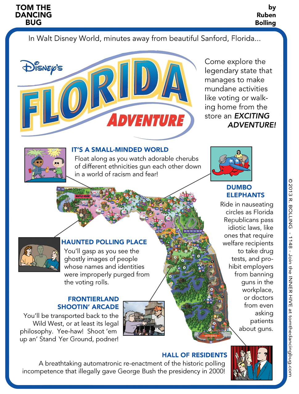
Florida Adventure
Oh, Florida! Will you ever be anything less than disturbingly odd? From Ruben Bolling's "Tom the Dancing Bug"
Thursday, July 25, 2013
Cannonball
Let's have a look-see at a cartoon from illustrator Jaco Haasbroek:

Fun, huh? He's got a lot more very cute illustrations on his site.
Fun, huh? He's got a lot more very cute illustrations on his site.
Wednesday, July 24, 2013
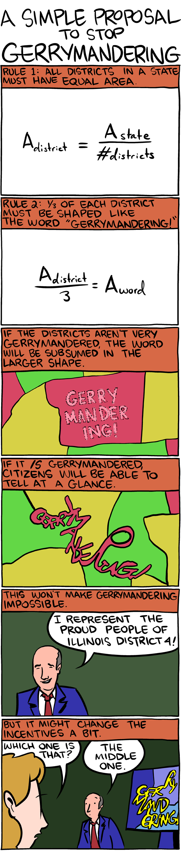
Solution to gerrymandering
A solution to gerrymandering from Saturday Morning Breakfast Cereal webcomic by Zach Weiner. Click on the image to embiggen for legibility.
Tuesday, July 23, 2013
Monday, July 22, 2013
Convention spill
This submission by Amanda is again from John Collins for the 1967 cartoonists convention. Photos of spills that look like maps abound on the internet.

Sunday, July 21, 2013
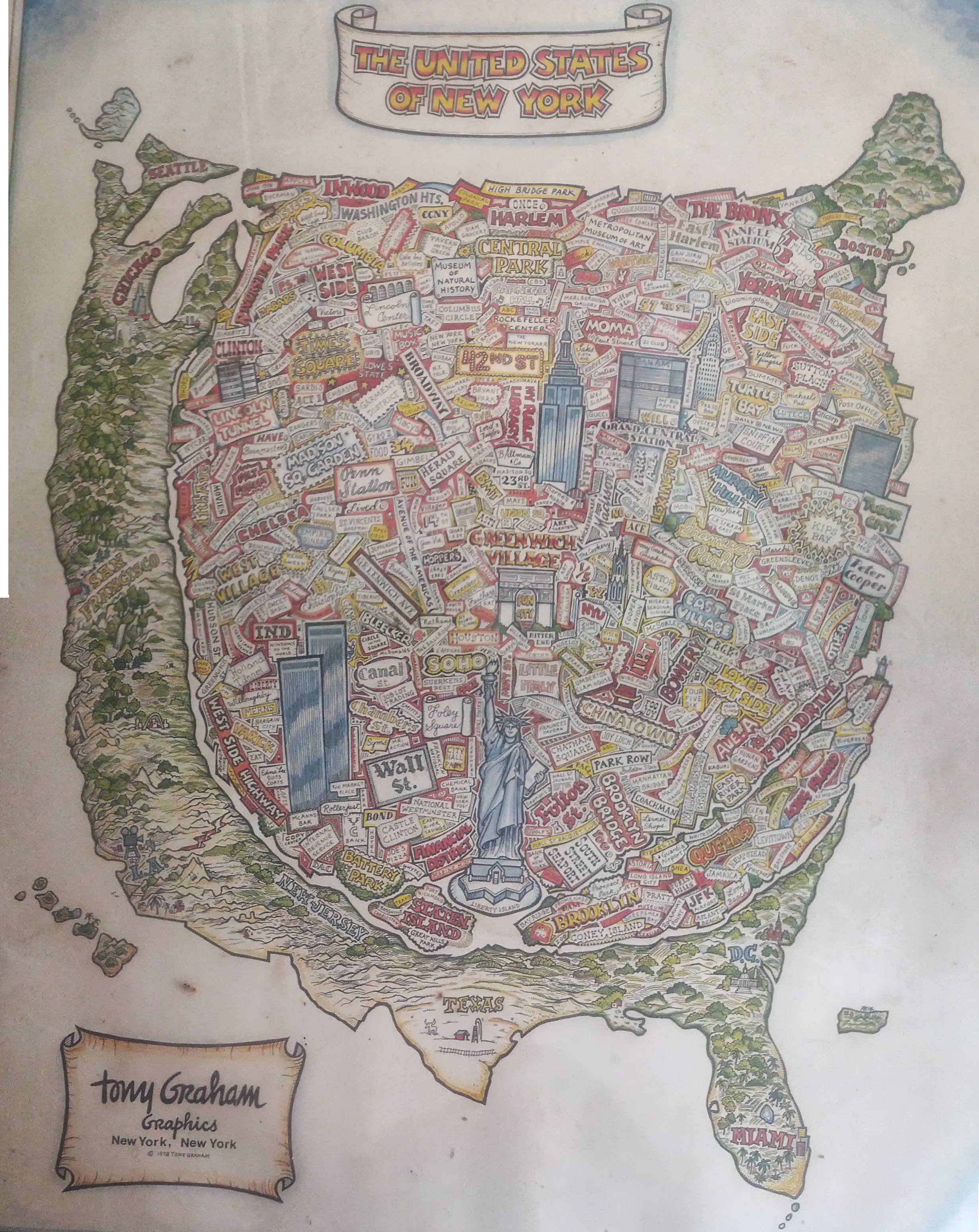
United States of New York
This 1978 Tony Graham
Graphics 'United States of New York' poster was found by some people cleaning out a basement.
Saturday, July 20, 2013
Friday, July 19, 2013
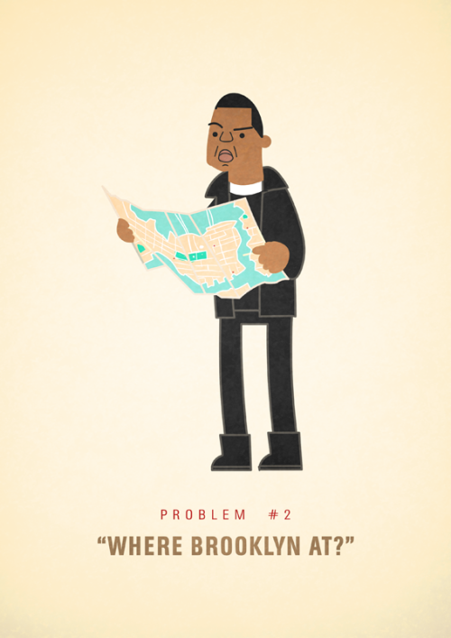
Problem # 2 of 99
Ever wondered what Jay-Z's "99 problems" are all about? Artist Ali Graham is doing his best to figure them out in his new Tumblr blog 99 Problems,
where he showcases color illustrations of Hova dealing with first world
rapper problems (as often referenced in his lyrics). Problem #2 is figuring out "where Brooklyn at." So
far, more than 40 of the rapper's problems have been illustrated, with the rest on the way..
Thursday, July 18, 2013
Seal porn
A little farther along in the plotline at the webcomic "Powernap" by Maritza Campos we have our hero Spencer making up some deeply lame story about looking at maps to avoid being caught looking for his team-mate/attempted-killer (remember the guy with way, way too many teeth from the last Powernap post? I suspect that's actually his boss there ... but that might be too easy). The seals? Inside joke from a couple episodes back.

Wednesday, July 17, 2013
Animated Empires
Animated GIFs of empires past? We gots 'em right here. I like the Mongol empire the best because it's ridonkulously massive. :

:


:
Tuesday, July 16, 2013

Monday, July 15, 2013

Sunday, July 14, 2013

Saturday, July 13, 2013
Heliocentrism
This is more astrophysics than cartography, but it's still an important principle in both fields: Jef Mallet's Frazz


Friday, July 12, 2013
Sabbatical
There's never enough cartoons about the earth complaining about the effects of humans on its health. Eldon Dedini in The New Yorker.
![]()
Thursday, July 11, 2013
Something beautiful
Pearls Before Swine by Stephan Pastis sometimes goes in for these depressing fables with the conceit that they're authored by the strip's "Rat" character rather than Pastis. The glob-looking thing in panel seven qualifies this as a map-related comic... kinda.


Wednesday, July 10, 2013
Tuesday, July 9, 2013

Monday, July 8, 2013
Get it right this year.
This item from Amanda is another John Collins cartoon from about 1946, the globe in the corner being utilized to symbolize a place of learning.

Sunday, July 7, 2013

Saturday, July 6, 2013
Bathroom break
Greg Cravens comic strip The Buckets on a family road trip with a TomTom. Remember the TomTom? That was a navigational device used by people in the ancient world of like 5 years ago before smart phones conquered the consumer-grade navigation marketplace.


Friday, July 5, 2013
Laugh them off the map
Here's an old 1940's-era cover for Harvard's storied parody magazine National Lampoon with an arguably racist response to the war.


Thursday, July 4, 2013
Party
This may be from a 1972 New Year's Eve issue of The New Yorker, but I think it still works well for a 4th of July theme.

Wednesday, July 3, 2013
On me
Remember when the US was big and powerful enough to do something like this? This is from a 1993 New Yorker cartoon by Mischa Richter. Who knows which crisis this was in reference to. The '90's were a pretty swell decade for the US.
Tuesday, July 2, 2013
New "Map" technology
Percy from my local open source GIS user group passed around this funny video about a "new" technology sweeping the location-based industry:
Monday, July 1, 2013
Lost the spare
This item from Amanda is another John Collins cartoon, this time referencing Canadian economic woes in the 1960s. Collins references the Canadian everyman with a character he calls Uno Who.

Subscribe to:
Posts (Atom)