To coincide with this week's international climate change talks in Paris Amanda has submitted this explainer comic by Richard Monastersky & Nick Sousans:
Atomic Robo is a webcomic about an atomic-powered robot invented by Nicola Tesla. It often has maps. This one is funny because it shows a character using a map like it's a mall directory rather than the map of the black market freighter in the middle of the Pacific as our heroes/fugitives prepare to re-assemble the titular character and (once again) save the world.
Other examples:
From Ahammaday.com. This one seems a bit off. Sure, the one astronoaut's looking the wrong way and his buddy is tapping him on the shoulder to turn around, but it just doesn't quite work somehow.
Thomas Jefferson established the square mile as a foundation for land law in the US. This instragram account shows images of things found in 1-square-mile crops from Google Earth. It's pretty:
Apparently some people thought this image/video was what the Earth would look like without water.
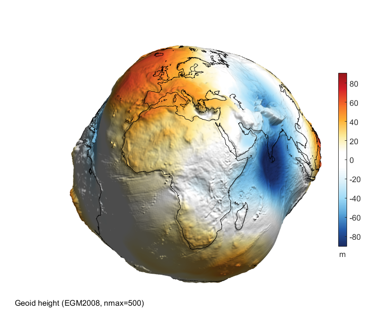
I't actually just the geoid, which shows the shape of the Earth's surface where gravity is the same (exaggerated for visual effect)
This is what the Earth would look like without water (which we've seen before):
"Friendly tag-based Javascript animators" JADSDS have made a gigantic HMTL5 map of the overworld from The Legend of Zelda: A Link to the Past, also known as the best Zelda.
This from Dorkly. We've mentioned the Maurader's Map from Harry Potter before. As clever as this comic is, it's hardly the only feature in the Harry Potter universe which could have cut short various plotlines.