
Friday, March 30, 2012
Woodcut Maps
Thursday, March 29, 2012
Illusory globe
How to make an optical illusion that looks like a globe. Neato!
"Vous êtes ailleurs" ou à l'Hôtel de Ville ? by mairiedeparis
"Vous êtes ailleurs" ou à l'Hôtel de Ville ? by mairiedeparis
Wednesday, March 28, 2012
Spider learnin'

Tuesday, March 27, 2012
River Transit Maps two-fer


Monday, March 26, 2012
Tracking the sea-doggies

Friday, March 23, 2012
What I do
This is on is from my friend and colleague Rob and it's an example of the What People Think I Do / What I Really Do meme which has spread like wildfire across the internet over just the last couple months. Enjoy:


Thursday, March 22, 2012
Mapping Everyday Heroes
Heroes Chronicles is an interactive site in Mexico dedicated to mapping the locations of regular people doing heroic things... though they've expanded now to include Kazakhstan for some reason. Check it out and map your own:

Wednesday, March 21, 2012
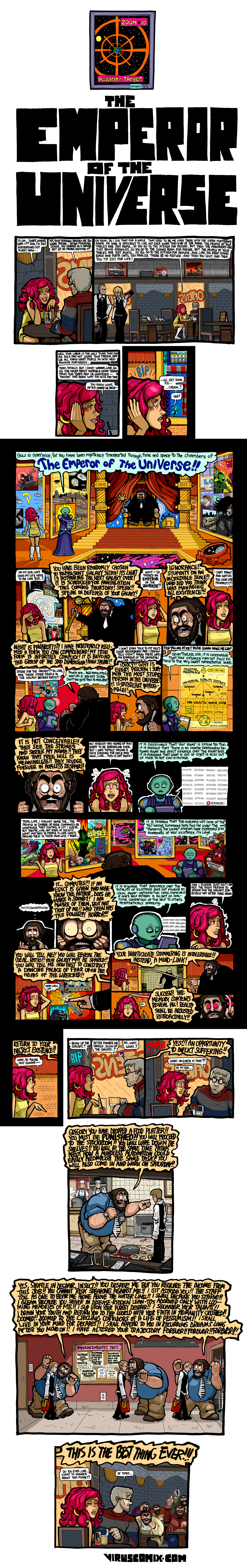
Emperor of the Universe
The always overwhelming Subnormality by Winston Rowntree gives us this peek into a difficult multiverse. There's a map or two in it, most notably the palace map about half way through. Click to make it larger/legible:
Tuesday, March 20, 2012
Rhode Island two-fer
For no particular reason, let's do some Rhode Island-themed cartoons for today's two-fer... And by the way, that leaves only 16 states left to be specifically mentioned in this blog:
Rhode Island dreamin' big (Rhode Island the colony actually was a LOT bigger than Rhode Island the state):

Rhode Island red, of course:

Click on this one to make it larger. There's a LOT of detail in it:

Rhode Island dreamin' big (Rhode Island the colony actually was a LOT bigger than Rhode Island the state):

Rhode Island red, of course:

Click on this one to make it larger. There's a LOT of detail in it:

Monday, March 19, 2012
Sponsored GPS

It very much reminds me of a time a few years ago when I was driving in the car with my son and the conversation maneuvered itself into a place where he was explaining to me the directions of how to get to some place we had been talking about. All of his directions were in reference to restaurants.. Things like "2 blocks past the Burger King" and "Turn left at the McDonald's"... only he wasn't only referencing fast food joints, he was also mentioning the smaller local joints... places I never noticed and often I had no idea which places he was even describing. What's more, we had never, ever been to any of them. We'd been to Taco Bell... a local burrito chain... and a food cart.... and that's it. We don't watch TV either, so he couldn't have learned of those places that way. But he was giving me all these directions using all these restaurants as if we knew all these establishments intimately. I was a little spooked, and very amused.
Friday, March 16, 2012
The Song Map
This is The Song Map available at the Dorothy site:
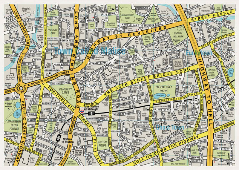 As one can see, all the street names, parks, and other features are taken from lyrics of songs. Want to hear the songs featured on the map? Here's a Spotify playlist of at least 353 of them: http://spoti.fi/wzBFnp
Thursday, March 15, 2012
Virtual world
Here is a video of a planet-sized virtual world. This was built using fractal algorithms based on actual Earth data. The first game being built using this engine, Anteworld, presents an Earth long abandoned by humanity and tasks players with rebuilding civilization. Here's an article about it at the Makezine site.
Wednesday, March 14, 2012
Restraining map of the stars

Tuesday, March 13, 2012
Super later primary two-fer Tuesday
While we're still in Primary season I figured we should do at least one more election primary two-fer. I have no idea how many more of these we'll have an opportunity to present, but as always, if you see any map-related comics during this primary season let me know.
The first is from Gingrich's Super Tuesday win in Georgia drawn by Mark Streeter. Anthropomorphizing a state can be difficult. Doing so in a way that makes it identifiable as a particular personality doubly so:

Chris Weyant gives us this take on the earlier primary in Michigan. The Mitt Romney - mitten-shaped state of Michigan relationship was an easy gimme. The trick is making it funnier than the simple sight gag:

Bill Day does a similar take on the same sight gag:

... but Day simply copy-pastes a gag he's done before during this primary season:

Monday, March 12, 2012
Fire break

Back in the summer of 2007 there were massive wildfires raging across the west. Pat Bagley created a map-related editorial comic on the subject.
Friday, March 9, 2012
Mapping March Madness
While I'm not much of a sports fan, I can certainly appreciate a convergence of geography and multi-billion dollar sports industries. For example, here is a map showing both the number of shots taken from various places on the court during NBA games from 2006-2011, and also the success rate of those shots:

And the same kind of map for an individual player,

Now, as the article I found these in suggests, imagine overlaying all of these plots for all the players on a team and make a team that knows how to distribute its players to most effectively shoot from any position on the court. This is the work of Kirk Goldsberry, an assistant professor of geography at Michigan State (and currently a visiting scholar at Harvard).
Thursday, March 8, 2012
Mapping WiFi with light
Here's a beautiful way to do some mapping: This is effectively a time-lapse photo of a guy holding a LED-loaded staff that lights up according to WiFi signal strength. Very fun! I think this counts as an instance of wardialing (or wardriving or warchalking)
This is from a research project by some guys in Norway.
This is from a research project by some guys in Norway.
Wednesday, March 7, 2012

Tuesday, March 6, 2012
9/11 Commission: The Graphic Novel
Remember the 9/11 Commission Report? If you never actually got around to reading it, here's the graphic novel version by Sid Jacobson and Ernie Colón serialized in Slate Magazine. It's an easier read... and uses quite a few maps (although I would guess that the original does too).


Monday, March 5, 2012
Ice cream tracking

Friday, March 2, 2012
Google Earh pie chart

Thursday, March 1, 2012
Sesame Street: Map Maker

Subscribe to:
Posts (Atom)